
Hit the Trails! The Best Hiking Spots in Colorado Springs North Cheyenne Canyon
This page contains affiliate links. If you make a purchase via a link on this page, we make a small commission at absolutely no extra charge to you. Thank you for your support of this small women-led business.
North Cheyenne Canyon: Where to Find the Best Hiking Spots in Colorado Springs
Seven epic hikes, one trailhead—North Cheyenne Canyon offers waterfall trails, mountain summits, and family-friendly adventures all within 20 minutes of downtown Colorado Springs.
Colorado Springs waterfall - Helen Hunt Falls
If you're after the best hiking places in Colorado Springs, North Cheyenne Canyon is the place to be! Just minutes from downtown, this 1,626-acre park offers stunning views, challenging hikes, and peaceful moments in pine and aspen groves.
With family friendly hikes and dogs welcome on leashes, it's perfect for everyone. Plus, all these cool hikes in Colorado Springs kick off from the convenient Seven Bridges trailhead, making it easy to return time and again.
Admission? Always free.
Open every day from 5 am to 9 pm. With over 56 miles of trails, there’s something for walkers, hikers, bikers, and pet lovers alike.
We’ve pulled together seven of our favorite hikes to get you started—and don’t miss a nearby geologic delight that will add a cool twist to your adventure!
North Cheyenne Canyon is one of the best hiking places in Colorado Springs, offering a mix of scenic trails, rock climbing routes, and waterfalls.
This park is a paradise for outdoor lovers, with each hike delivering a unique adventure.
Start at the Seven Bridges trailhead, where you’ll follow a babbling creek and cross—you guessed it—seven charming bridges.
Up for a challenge?
Kineo Mountain dishes out killer Pikes Peak views, while Loud’s Cabin lets you time-travel to some old log cabin ruins. May’s Peak serves up sweeping views of downtown, and St. Mary’s Falls is a stunning reward after a solid hike.
And if you’re not ready to call it a day just yet, swing by Helen Hunt Falls—a Colorado Springs waterfall—for a quick, scenic stop just down the road.
This easily accessible waterfall is the perfect way to wrap up a day on the best trails in Colorado Springs, whether you want to snap a few photos or just enjoy the sound of rushing water before heading home.
Plus, stick around—we’ll be sharing a nearby natural geologic wonder that you won’t want to miss!

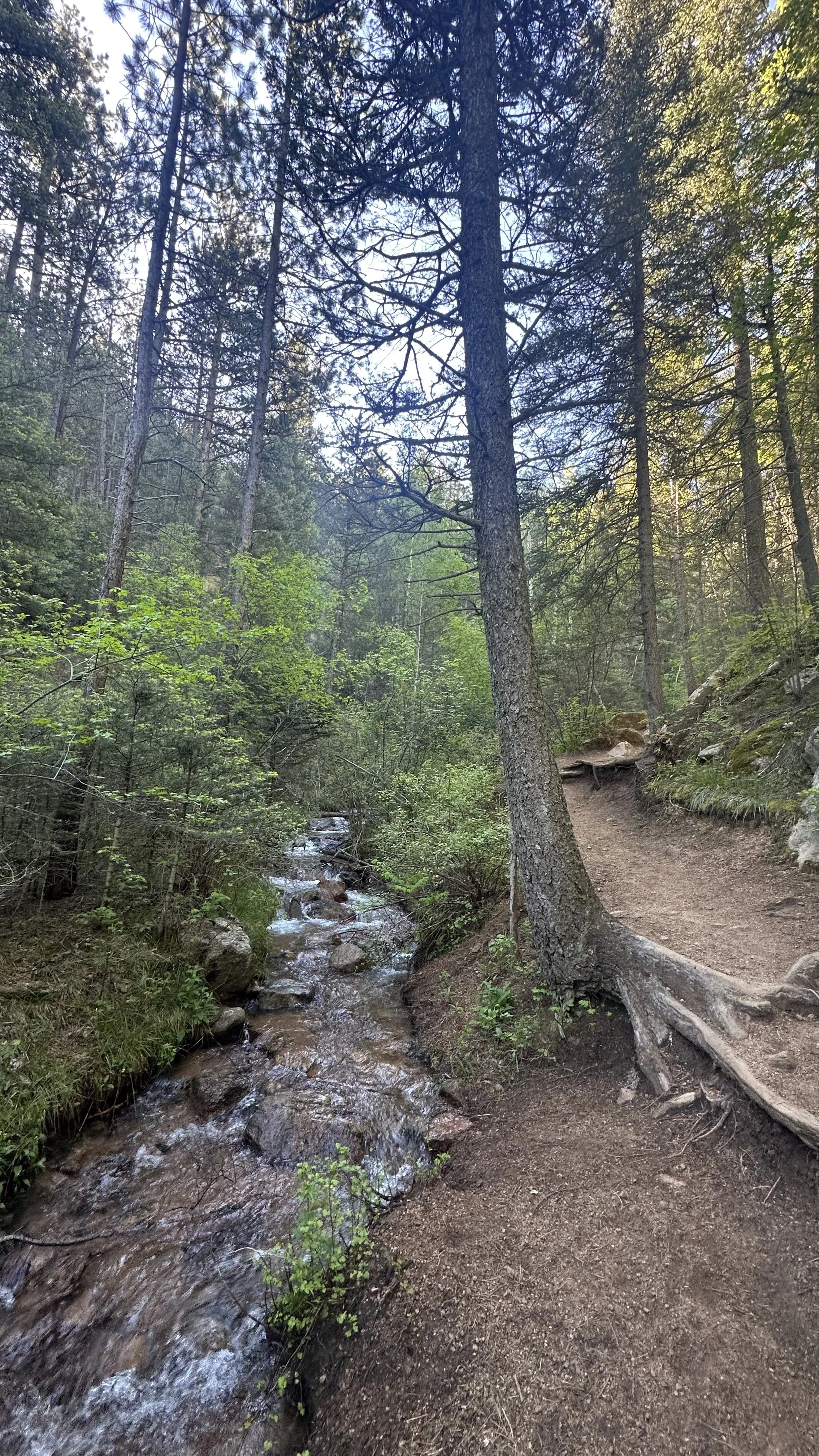
One of many cools hikes in Colorado Springs, 7 Bridges is gorgeous year round.
Many of the best trails in Colorado Springs start right at the Seven Bridges trailhead, just 20 minutes from downtown.
This spot isn’t just home to the classic Seven Bridges Trail—it’s the gateway to a whole network of hikes.
Whether you’re looking for a family-friendly hike along the creek or a tougher climb up to sweeping views, you’ll find it here.
From waterfall trails to summit treks, this trailhead is the perfect launch point for an epic day outside.
Table of Contents
Getting There and Where to Start
Seven Bridges Trail *Easy
Kineo Mountain Trail *Moderate to Hard
Louds Cabin *Moderate
St Mary’s Falls *Moderate to Hard
May’s Peak *Easy
Mount Garfield *Hard
Mount Rosa via Cheyenne Canyon *Hard
Colorado 7 falls
Nearby Places to Eat
Where to Stay
How do I get to Seven Bridges?
Colorado Springs Seven Bridges Trailhead is located in North Cheyenne Canyon Park.
When there is no construction, this park is easy to access off West Cheyenne Road.
Alternate route: Take exit 141, Hwy 24 toward Cimarron. Left on 21st road. Turn right on to Argus Blvd passing by Bear Creek Nature Center. Turn left and go up Gold Camp Road, road number 370.
Be prepared that Gold Camp Road is approximately 4 miles of rough-grade gravel road to the parking lot.
NOTE! You will pass through 2 tunnels before reaching the parking lot.
Once you are on Gold Camp Road, you’ll be within 4 miles of the trailhead parking.
Where can I find parking for hiking Seven Bridges?
This is the overflow parking lot - just down the road is the main paved parking lot for Seven Bridges trailhead.
Seven Bridges is one of many good hikes in Colorado Springs, which often means parking fills up fast—especially on weekends and warm-weather days.
The newly paved lot has plenty of spaces, but in peak summer months, it’s full before you know it. For the best shot at a spot, plan to arrive before 7 a.m. or after 2 p.m. on weekdays.
Weekends? Expect a crowd.
You’ll find 3-4 porta potties at the trailhead, though cleanliness is… let’s just say, hit or miss.
The Seven Bridges parking lot is a busy hub for hikers, bikers, and motorcyclists. Nearby, Captain Jack’s Trail is a go-to for motorbikes and cyclists, so expect a little extra activity in the area!
How to find the Seven Bridges Trailhead
The Seven Bridges trailhead
From the main parking lot, you’ll note several large signs and a gate to the left of the porta potties. Head towards this gate, hiking along a very wide sand and gravel road for about a mile.
There is little shade in this section.
The actual 7 Bridges trailhead is a bit hidden. Round the bend after seeing a rushing river to your right.
Once on the trailhead, hike on path with river to your right.
There is some confusion at the beginning with splinter trails created by lost hikers. The river/stream is your guide. Stay by her and you’ll find your way.
LOCAL TIP! No matter the time of year, sun protection is your friend on the best hikes in Colorado Springs. We love our OR sunhats, Patagonia sun shirts and 40 SPF sunscreen!
On a summer hike in North Cheyenne Canyon, I paused mid-trail to appreciate my Osprey backpack—because when your gear works this well, it deserves a shoutout.
See why I swear by it for all these cool hikes in Colorado Springs!
What should I wear on the best hikes in Colorado?
OUR GO-TO GEAR FOR COLORADO HIKING TRAILS IN 2025:
We love the Osprey Sirrus Hiking Daypack for women, or the Osprey Stratos version for men, for carrying water, layers, and snacks on Colorado day hikes
Free Fly’s High Mile Jogger is the perfect hiking pant! Comfy, stylish and durable!
Lightweight, versatile Hiking Poles built for a full day’s send on the trail — hike longer and stronger
2L or 3L Water Reservoir — This affordable reservoir is easy to fill
Patagonia Torrentshell - a true waterproof rain jacket and fantastic layering piece
Nano Puff Jacket - our favorite for 3 seasons in Colorado
Smartwool Glove Liners - the best all season gloves for those high altitude hikes
Salomon hiking shoes - waterproof, comfy and hard working for any type of hike
We put together a super simple checklist for what to wear in every season on cool hikes in Colorado Springs. This Colorado capsule wardrobe helps keep those “oh no” moments—like forgetting layers—at bay.
Click below for the link!
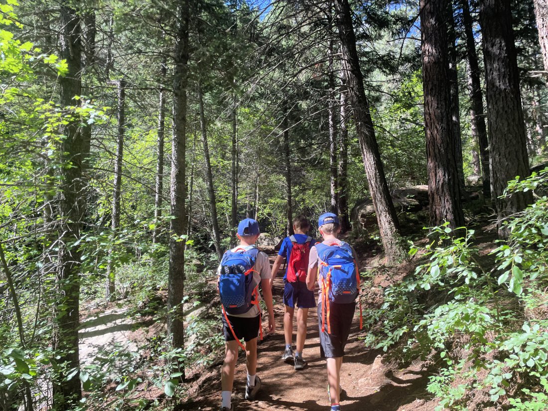
One of the best hiking spots in Colorado Springs, Seven Bridges trail!
Seven Bridges Trail
Length: 3.8 miles | Elevation Gain: 1,046 feet | Route Type: Out and Back | Difficulty: Easy to Moderate
New to Colorado Springs or visiting? This is one of the best hiking spots in Colorado Springs!
Seven Bridges Trail is one of our favorite hikes for out-of-town guests. It’s a relatively short trek but delivers big on scenery—waterfalls, rolling hills, towering pines, and, of course, the iconic bridges.
Literally one of the coolest hikes in Colorado Springs with it’s raging river!
Located in the heart of North Cheyenne Canyon Park, this trail stays busy most months.
Start early or arrive late to dodge the crowds. Then again, sometimes midday is the sweet spot when the morning rush has cleared out!
This trail is the hub for so many spectacular cool hikes in Colorado Springs. Nestled in North Cheyenne Canyon, it’s the perfect starting point for adventure, whether you’re chasing waterfalls, summiting peaks, or just soaking in the pine-scented air.
Begin hike down a gravel road for about a mile. It is a wide road without shade. You’ll see the trail sign to the right. Take the trail and start hiking along the river.
Some of the trail is rocky and steep while other parts are relatively flat.
Each bridge is marked along this Colorado Springs hike, making it easy to track your progress. In the fall, red scrub oak adds a pop of color, while lush green pines shine year-round. The pictures say it all—this is an easy, family friendly trail that even a flatlander can handle!
Plan on 90 minutes to 2 hours to complete this hike, depending on how many stops you make and how well you’ve acclimated to the altitude.


This area has some of the best trails in Colorado Springs for families.
Seven Bridges is one of those hikes. Make sure to include some downtime for your kids to dip their feet in the water. It’s icy cold, but oh so refreshing! This is a great Colorado Springs waterfall hike, with each bridge crossing over small, cascading falls, creating a scenic and refreshing journey for the whole family.
There are sections of dry ground shaded by enormous trees creating the perfect rest stop. Please remind your kids to keep the rocks and pebbles in the creek.
Take in the stunning views of Colorado Springs from Kineo Mountain’s summit.
Kineo Mountain
Length: 6.0 miles | Elevation Gain: 1,955 feet | Route Type: Out and Back or Point to Point | Difficulty: Moderate
Once you reach the 7th Bridge on the Seven Bridges Colorado Springs Trail, stay to the left as you follow trail 622. *Make sure to follow the PURPLE/PINK paint that acts as markers.
Following these markers is particularly helpful through the large boulder and loose rock section just after you pass the 7th bridge.
Boulder section after the 7th bridge, one of the many hiking places in Colorado Springs with snow throughout winter.
Just past the 7th bridge, the trail steepens and becomes rocky as you head left. Hiking poles are helpful here, and we highly recommend adding spikes or traction, as many areas remain icy throughout the winter. Be cautious—this section is high above the cascading waterfalls with steep drop-offs.
When you feel like the uphill climb just has to end, you'll arrive at a spectacular aspen grove. No matter the season, this grove offers gorgeous views. We especially love it during Colorado fall hikes, when the aspen colors peak, typically in early October.
Just past the grove expect a final section of uphill hiking. Perhaps a 1/4 mile long, arrive at a large area marked with several trail signs.
Aspen groves like this make these hiking spots in Colorado Springs so fun to explore!
When you reach the junction for Trails 667 and Jones Park, the Kineo Mountain trailhead is unmarked but located to the right.
Note large tree stump and cairn. This is your trailhead marker for Kineo’s summit
Look for a large tree stump with a small cairn (a pile of rocks that looks like a pyramid) nearby.
This marks the trail. Head towards the cairn and tree stump, and the trail will soon appear.
This is one of the hidden gems among hiking spots in Colorado Springs!
The last quarter-mile is especially steep, but once you pass a giant cluster of rocks, the summit is close.
As you approach the first summit area, head to the right, where you’ll find a large, exposed section.
To your left, there’s a tree grove, while more hillside stretches to the right.
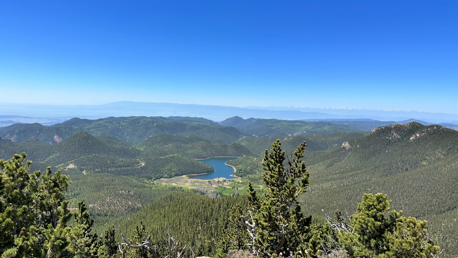
This spot is perfect for a quick pause to take in the surrounding views before continuing onward. Once you reach the top, there’s plenty of room to find the perfect rock to sit on and soak in nearly 360-degree views of the mountains and downtown Colorado Springs—this trail truly ranks among the best trails in Colorado Springs because of these stunning vistas.
Summit view at Kineo Mountain
You’ll even catch a glimpse of the Broadmoor ziplines in the distance.
It’s the perfect place to pause, relax, and take in the beauty that surrounds you. This is a less traveled trail, the perfect spot for some quiet meditation and why we rank it high on the cool hikes in Colorado Springs list. Melody has met some of the coolest local hikers on Kineo’s summit.
Heck, you might even meet her up there as this is her favorite trail in North Cheyenne Canyon!
Most of Buckhorn Trail is red gravel rock. Hiking poles really help!
Buckhorn Trail Loop from Kineo Mountain
For more mileage and different views on the way back (plus a gentler downhill that’s easier on the knees), head down Kineo Mountain, turn right, and take Trail 667 (Buckhorn Trail). This trail offers beautiful trees and expansive views of the large ravine.
NOTE! Bikers love this section, so keep your ears open and step aside when necessary. While hikers technically have the right of way, downhill cyclists can move quickly and may not always be able to brake in time.
Trail runners also frequent this loop, and you might even pass an Olympian training nearby, as it’s close to the Olympic Training Center.
*We love Black Diamond trekking poles for Colorado hikes. They fold up neatly, perfectly content to hang on our packs until needed for trail sections like this.
DID YOU KNOW? From the summit of Kineo Mountain, you can see ziplines. Zipline adventures can be tons of fun if adrenaline is your middle name. We share how to get on these ziplines along with over 50 free or almost free things to do in and around Colorado Springs!
Louds Cabin in North Cheyenne Canyon park
Louds Cabin
Length: 6.2 miles | Elevation Gain: 1,778 feet | Route: Out and Back or Point to Point | Difficulty: Moderate
This hike in Colorado Springs is rated moderate, mainly due to the steep, rocky section past the 7th bridge to the 622A trail junction. The terrain can be rocky, as you’ll see in the video.
Loud's Cabin hike is one of our favorite winter hikes and definitely qualifies as one of a handful cool hikes in Colorado Springs!
Most of the time, spikes work fine along the trail, but as always, check the weather and grab your snowshoes if there's been a recent snowstorm.
This trail is shaded in spots, so the snow lingers for months, making it a perfect winter destination.
If you're on the hunt for the best trails in Colorado Springs, this one's a top choice with its beautiful views and winter wonderland vibes!
Take the same trail you would for Kineo Mountain.
After reaching the 7th Bridge, turn LEFT onto 622A, following the stream. You'll encounter some boulder scrambling in sections, and it’s a steep climb.
Continue across a wide sandy field with a high drop-off towards the river—if you're afraid of heights, be cautious!
While portions of the trail have snow, it’s typically packed down. Traction and gaiters work fine for keeping upright.
This stretch through the aspen grove is a steady uphill but a beautiful trek, especially in fall when the golden leaves glow.
In winter months, snow blankets this area and often sticks around all season.
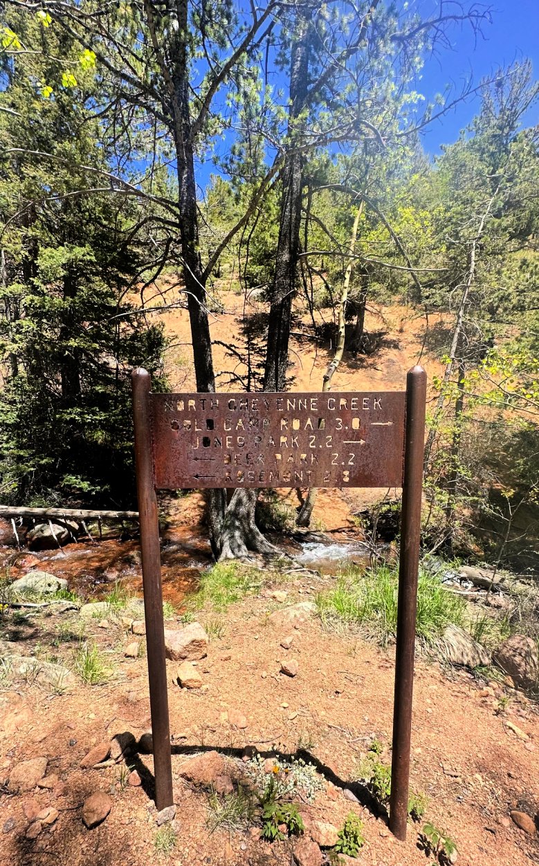
Just past the aspen grove, you'll reach a wide-open junction where Kineo Mountain, Louds Cabin, and Jones Park trails intersect.
Look for Trail 622A just to the left of a large area map sign.
Winter hikers should be prepared for deep snow. While gaiters and traction help, expect a slower pace.
Downloading a map is a good idea, as the trail is easy to follow in summer but can be harder to spot under winter snow.
If you're looking for hiking spots in Colorado Springs that offer a mix of history and adventure, this route is a great choice. From the intersection, Louds Cabin is about a 20-minute trek downhill, where you'll come across old cabin ruins and scattered equipment—a quiet glimpse into the past.
DID YOU KNOW HOW LOUD'S CABIN GOT ITS NAME? SPOILER: IT’S NOT ABOUT THE VOLUME!
Frank Loud wasn’t just any mountain man—he was a math professor at Colorado College who swapped equations for mountain air every summer.
He, his wife, and their child would retreat to this high-altitude paradise, where he cultivated wild plum trees and other crops, proving that even mathematicians can have a green thumb.
Today, two of Loud’s cabins still stand, including his main residence, Chipmunk Lodge.
The most striking remnant?
An impressive 8-foot stone chimney rising from a tangle of toppled log walls—a true relic of Colorado Springs history.
If you visit, remember: look with your eyes, not your hands or feet! Let’s keep this mountain treasure intact for the next curious hiker who stumbles upon it.
Related Links:
Curious to learn more about Colorado Springs wild west history? Colorado Springs Pioneer Museum has wonderful interactive historical exhibits free of charge.

HIking to St Mary’s Falls is a pretty cool deal, literally.
St Mary’s Falls via Seven Bridges Trail
Length: 6.3 miles out and back | Route Type: Out and Back | Elevation Gain: 1,397 | Difficulty: Moderate to Hard

This Colorado Springs waterfall trail will get your heart pumping with a steady incline, but take it slow, and you’ll be just fine!
It’s a must-add to your Colorado Springs hikes to-do list. The upper portion can be slick in winter and loose with gravel in warmer months, so sturdy footwear is key.
Not sure what to wear on the trails? Check out our guide to the best hiking shoes, boots, and trail runners!
You’ll begin at the parking lot, taking the mile or so to the Seven Bridges trailhead sign.
DON’T TURN ONTO THE SEVEN BRIDGES TRAIL!
Look for this large cave as you head up the gravel road.
Keep on the wide gravel road to the left.
You’ll follow this wide gravel and sand road up rather steep hill. Take a moment to stop and look around at the gorgeous backdrop of the Colorado mountains.
Once you pass a large cave-like structure on your right, look for trail marker 624.
NOTE! If you’re hiking this in the winter, keep in mind that the trail might be hard to see when covered with snow, especially at the very top.
Take TRAIL 624. Near the top, head left, as if you’re walking in the creek.
You’ll see the trail steps. Continue on until you reach the falls. In summer months, this is well marked area. People hike this trail often, creating an established trail.
Consider going the last 500 feet or so up the trail. The base of the fall is gorgeous, even in the winter when it’s frozen.
This is a stunning Colorado fall hike, lit up with gold aspens and scrub oak reds.
PRO TIP! In winter be careful of ice, particularly the last stretch of the trail. Grab your YakTrax or spikes for an easier climb.
For More Miles Along This Trail…
Follow the dirt road to the left—technically Old Gold Camp Road—toward Mary's Falls. Along the way, you'll pass through a series of long, spooky tunnels, a historic route that once led to Cripple Creek.
From here, you can take a trail toward Cheyenne Road, which leads to Columbine and the parking lot, or continue hiking to Mt. Cutler and Muscoco for more adventure.
May’s Peak
Length: 3.2 miles | Route Type: Out and Back | Elevation Gain: 777 feet | Difficulty: Easy
This is the perfect Colorado sunset hike! As one of the easiest trails in Cheyenne Canyon Park, it’s also one of the best hiking places in Colorado Springs to catch breathtaking views and a glimpse of Helen Hunt Falls.
Most of the trail is well marked along dirt trails.
Whether you're here for a peaceful evening stroll or the ultimate golden-hour selfie, this trail delivers.
Ideal for families and beginner hikers, the well-marked path has minimal obstacles.
The biggest challenge?
Finding parking at sunset!
Spaces fill quickly, and parking in undesignated areas means a hefty ticket. The good news? Once the lot is full, the park closes the gates, keeping the trail peaceful for those lucky enough to snag a spot.
Where to Park
Park at Captain Jack’s Parking Lot, the first lot on your right after passing through the second tunnel on Gold Camp Road.
While this hike doesn’t technically start at Seven Bridges, you’re close enough that it’s worth mentioning!
Begin this cool hike in Colorado Springs on High Road. As you start, you’ll see a few trail options—Captain Jack’s to the right and May’s Trail furthest right behind the metal handrails.
The first half of the trail follows a wide gravel path, transitioning into a narrower, forested section. The final stretch gets a bit steep, so pace yourself and enjoy the climb!
NOTE! If you're looking to add more miles, start from the Captain Jack’s Trailhead in North Cheyenne Canyon, the closest trail to the parking lot. This route creates a six-mile round-trip hike. However, keep in mind that Captain Jack’s Trail is popular with ATVs and mountain bikers, especially on weekends, when they tend to dominate the trail.
Related Link:
Looking for more beautiful sunset hiking places in Colorado Springs? We have a roundup our favorite short and easy hikes in Colorado Springs.
Mount Garfield Peak
Length: 9.7 miles | Route Type: Out and Back | Elevation Gain: 3,480 feet | Difficulty: Moderate to Difficult
We attempted to summit in January, but with thigh-deep snow and a barely visible trail, it proved challenging. Our biggest mistake? Not downloading the map before heading out.
Below is the route we took toward Mount Garfield Peak—following the same path as you would for Loud’s Cabin, one of the many good hikes in Colorado Springs worth exploring.
NOTE! Cell reception is unreliable on most trails in North Cheyenne Canyon, so plan accordingly.
Start at the Seven Bridges trailhead and head toward Loud’s Cabin. Stay on Trail 622A, and you’ll be all set.
Once you reach Loud’s Cabin, look for a faint trail to the right, passing through a meadow with cut logs arranged in a circle and large trees overhead. Follow the trail uphill.
While there was a TON of snow when we hiked this, we managed to find the trail.
We made it as far as the boundary of the National Forest, where you’ll want to stay left of the sign. We ventured a bit further but had to turn around due to snow and time.
Locals tell us the last mile is a steady uphill, unmarked trek, often compared to the scree on a 14er.
Not for the faint of heart or those struggling with altitude, but the views are absolutely worth the effort.
Many hikers in the area claim this is one of the best hiking spots in Colorado Springs, and after seeing their pictures, it’s definitely on our bucket list!
View of Pikes Peak from Mount Rosa Summit
Mount Rosa via Pipeline Trail
Length: 13.9 miles | Route Type: Loop | Elevation Gain: 4,202 feet | Difficulty: Hard
Mount Rosa is the pointy shaped mountain in Colorado Springs just south of famous fourteener, Pikes Peak. Three main ways to hike Mount Rosa, Melody tackled the longest loop!
Always up for a challenge solo hiking, trekking along Mount Rosa via Pipeline Trail easily makes the cool hikes in Colorado Springs short list. Start early and pack strategically.
NOTE! For this almost 14 mile hike, bring at least 3 liters of water. Carry a water filter and replenish along the way. This route has plenty of water sources throughout the hike.
For a detailed map of the trail, check out the route Melody took. A loop hike, heading clockwise allows you to tackle most of the elevation the first half of the trail.


THINGS YOU NEED TO KNOW TO TAKE ONE OF THESE COOL HIKES IN COLORADO SPRINGS!
The terrain is unforgiving in winter. Don’t attempt to do this route unless you’re proficient in winter hiking, having the proper gear and know what the weather is.
You will share part of this trail with all terrain vehicles. Avoid on weekends and be prepared for long stretches of hiking in sand.
Enjoy solitude for most of this hike, making it the perfect solo hike!
Download a map. Better yet, bring a Pocket Pals map with you. You’ll need to consult it as you venture. The trails are not super well marked.
Go on a week day to avoid potential run ins with motors. The day Melody hiked this loop, she saw no one until reaching Seven Bridges.
Pocket Pals Trail Maps are helpful in planning these hikes on Cheyenne Canyon Trails. You will need both maps #2 and #3 — these are fantastic waterproof, tear-resistant maps. They also offer immediate digital downloads if you prefer.
Melody downloaded All Trails map of the area. Being directionally challenged, she also took along her trusty old school compass to help navigate.
Once you descend Mount Rosa, look for TRAIL 672 and take it. Stay on this trail until you arrive at a gate of sorts. This area has ample parking for all terrain vehicles. This portion is a shared trail with ATVS.
Be on the lookout for TRAIL 701, your next portion to hike.


TRail 701
Hiking in especially wet summers, expect a lot of water along this trail. A very shaded portion of the trail, it is lovely walking alongside the streams.
A rolling hill section, this portion of the loop trail is very pleasant. Quite the reprieve after a severe downhill from Mount Rosa’s summit.
A rusty metal trail sign gives you options for the next bit. Add on more mileage and do some segment hiking to the left. OR stay on course with this loop trail and head towards Jones Park.
Walk along this lovely stretch, enjoying the solitude of the moment.
Connect to the Ring the Peak Trail to Pipeline Trail.


While a small sign, you won’t miss the gigantic pipeline embed in the trail. Follow this section until reaching the final miles of this loop.
As you cross the stream one final time, take a right hand turn toward Seven Bridges. Head left and you’ll be going up the hill toward Kineo Mountain.
For your final miles of this loop hike, hike down Seven Bridges.
After journeying on a mostly solitude hike, expect to run into many happy hikers out enjoying Seven Bridges.
A truly magical loop trail, make sure you have plenty of water, take breaks and most of all, ENJOY EVERY MINUTE!

Colorado 7 Falls Waterfall Hike photo cred: Amie Lind
Colorado 7 Falls Waterfall Hike
Length: 1 mile | Route Type: Out & Back | Difficulty: Easy to Moderate
Colorado 7 Falls is one of the most stunning Colorado Springs waterfalls, offering a seasonal opening from March to December each year.
This beautiful 2-mile hike starts on a paved road that leads to the falls, followed by a climb up many stairs for breathtaking views.

Stairs up Seven Falls photo cred Amie Lind
Along the way, Falls Trail connects to Inspiration Point Trail and Sunrise Trail, which can take you further into North Cheyenne Canyon.
As the only waterfall in Colorado featured on National Geographic's list of international waterfalls, Colorado 7 Falls is a must-see destination.
Owned by the iconic Broadmoor Hotel, admission starts at $23 per person. During winter months, the falls are illuminated by gorgeous lights, creating a magical atmosphere.
Long before tourists climbed the stairs at Colorado 7 Falls, the Ute people used this canyon as a natural hunting ground, driving buffalo into its narrow walls. As Colorado’s oldest continuous residents, they moved with the seasons, living off the land and seeing the towering cliffs and Colorado Springs waterfall as a sacred place.
Today, you can hike the same scenic trails they once walked, soaking in the same breathtaking views—just with better shoes and fewer buffalo.
Whether you're exploring in the warmer months or visiting during the winter for the lights, this is a wonderful spot to experience a truly spectacular Colorado Springs waterfall.
From North Cheyenne Canyon, Nearby Hops
Sacred Grounds Coffee sHOp
1801 Cheyenne Blvd, Colorado Springs, CO 80906
With an enchanting outdoor patio for warm weather days, this coffee shop delivers the best espresso a hiker could want. Hungry? Order up a sandwich or pastry. Locally sourced food with adult drinks available.
Just minutes from Colorado Springs North Cheyenne Canyon Park, this should be high on your must stop list!
Trails End Taproom
3103 W. Colorado Colorado Springs, CO
A self-pour tap local hangout, choose from a variety of 1 ounce local beers and liquors or have a pint of your favorite beer. We love the friendly vibe of this taproom with many bikers and runners gathered in groups after just getting off the nearby MIdland trail.
Food trucks outside provide great grub.
Ivywild School
1604 South Cascade Colorado Springs, CO
Just a few miles from Colorado Springs Cheyenne Canyon park, former elementary school’s remodel is a unique stop.
Home to one of Colorado Springs first craft beers, Bristol Brewing Company offers many local beers including their famous Laughing Lab and Beehive.
Fossil Craft Beer Co
2845 Ore Mill Road, Suite 1 Colorado Springs, CO
IPAs, seltzers, dark brews are all on tap here. There is a year-round patio with different food trucks daily. This is a great spot for all.
If you are a fan of craft brews, Colorado Springs has dozens to pick from. We took the guesswork out for you, creating a post of the Spring's breweries, locations and areas of town.
Where to stay in Colorado Springs
Colorado Springs is one of Colorado’s most popular vacation destinations. This historic town is filled with fun attractions such as Garden of the God’s Visitor and Nature Center and the Olympic and Paralympic Museum.
Book a beautiful vacation home near these hiking spots in Colorado Springs.
More Fun Hiking Places in Colorado Springs
15 Happy Hiking Spots in Colorado for Families: Adventures Kids Will Love
Palmer Lake, just north of Colorado Springs, offers beautiful trails around the reservoirs. Bring a hammock for some down time.
Find the Best Paved Walking Paths in Colorado Springs - strollers, bikes and runners welcome!
