
Westcliffe Colorado Adventures in the Sangre de Cristo Mountains
This post may contain affiliate links. This just means if you click through and make a purchase, we may make a small commission at no extra cost to you.

Discover hiking and all sorts of outdoor adventures in Westcliffe, Colorado.
This quiet gem of a town is gently settled between the Wet Mountains and the Sangre de Cristo Mountain Range, just on the other side of Great Sand Dunes National Park and Preserve.
This Custer County town is also home to big ranches, tidy hay farms, and unmatchable dark night skies over the Wet Mountain Valley.
Off the beaten path, you’ll love Westcliffe’s Main Street plus the area’s off-road trails, alpine lake hikes — bring your fishing rod! — and fabulous views.
We made a bee line to Westcliffe one late summer weekend in search of camping and hiking trails. Since we had our friend’s jeep, we surprisingly opted for more off-road adventures on four wheels than the two-feet kind.
Our friend’s jeep easily took us up to an alpine lake to die for, great for paddle boarding and fishing. Thanks to Taurin at All the Range Mountaineering Outdoor Gear Store for the great tip and the much needed Sangre de Cristo trail map! Read more about getting to Balman Reservoir below.
In this post we will skim over lots of great things to do in Westcliffe CO and the Wet Mountain Valley like hiking, ATVing, off-roading, paddling, and enjoying dark night skies at the local observatory.

Lower Sand Creek Lake via Music Pass
Hiking in Westcliffe
The elevation of Westcliffe Colorado stands at 7,781’ in the Wet Mountain Valley. With the help of some hiking friends, let us introduce five of the best hikes in Westcliffe.
While these are long and challenging hikes, on some of these routes you could opt for turning around sooner, thus making them shorter hikes. You’ll still experience some fantastic views, to be sure!
Also, the roads to reach the trailheads for many Westcliffe hikes are rough and bumpy, so a high clearance AWD or 4WD vehicle is often needed.
Which one of these Colorado hiking trails will you be adding to the top of your bucket list?
Music Pass to lower and upper sand creek lakes
9.9 Miles | 2395 Feet Elevation Gain | Out and Back Route
If you like to fish, you’ll want to bring your rod on this gorgeous hike to Lower and Upper Sand Creek Lakes via Music Pass. You will end up above treeline at 11,749 feet high in this amazing part of the Sangre de Cristo Mountains.
While it’s a tough 2.5 mile drive on a rough 4X4 road, you’ll find the hiking trail to Music Pass well-maintained and easy to follow. The unforgettable views coupled with steep hiking only in small sections make this a lovable hiking or backpacking trip.
My friend Mandie completed the backpacking trip to Lower and Upper Sand Creek Lakes via Music Pass in mid-June and now it’s high on my bucket list! I plan to hike up there this fall.
The trail begins with a climb through the forest to the top of Music Pass on Music Pass Trail.


At 1.1 miles in, you’ll cross the border for the Great Sand Dunes National Park and Preserve. Take the little detour to the rock outcropping for some of the best views in the Sangre De Cristo Mountain Range.
Once you begin to descend into the Sand Creek basin, hiking poles are really helpful.
Here you’ll be about 3.4 miles into your hike. Don’t miss the left—hand spur to Lower Sand Creek Lake. The scenic views are worth the 2.4 miles out and back before you head to Upper Sand Creek Lake.
Possibly after a snack or some fishing on Lower Sand Creek Lake or the actual Sand Creek, backtrack to the trail junction and follow signs for about 1.5 miles to Upper Sand Creek Lake on the Upper Sand Creek Trail. Anglers report outstanding fly fishing for hybrid cutthroat trout.
Hiking the Music Pass Trail near Westcliffe comes highly recommended for amazing views, creeks, and backpacking to these cool alpine lakes. My friend said Lower Sand Creek is the prettiest of the two, so don’t stress if you don’t reach the upper one.
How to reach the Music Pass trailhead: From Westcliffe, you’ll hop on FS 119 towards Grape Creek Trailhead. Keep going up: a 2.5 mile drive on a tough 4X4 road with a high clearance vehicle with AWD or 4WD. Trail is usually well maintained and easy to follow and not too steep considering the elevation gain! Follow map directions from All Trails page for Upper and Lower Sand Creek Trail.
If you don’t have a high clearance vehicle, but you enjoy long hikes, park near the Grape Creek Trailhead, and start your hike from there, adding 5 miles total to your hike. From there, if you just go to Lower Sand Creek Lake (the more scenic lake), you’ll log nearly 12 miles round trip.
WHAT TO WEAR AND PACK FOR YOUR HIKE
How do you know what to wear and pack for Colorado hiking trails? Spend any time in Colorado and you’ll quickly learn to be prepared for any type of weather, no matter the season.
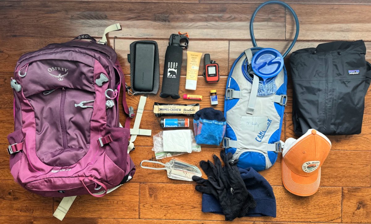
Here’s what keeps us going on our adventures while hiking in Colorado:
We love the Osprey Sirrus Hiking Daypack for women, or the Stratos version for men, for carrying water, layers, and snacks on Colorado day hikes
Lightweight, versatile Hiking Poles built for a full day’s send on the trail — hike longer and stronger
2L or 3L Water Reservoir — This affordable reservoir is easy to fill
Patagonia Torrentshell - a true waterproof rain jacket and fantastic layering piece
Nano Puff Jacket - our favorite for 3 seasons in Colorado
Sun hoodie - a must have in Colorado
Med kit
We’ve got your full checklist of daypack essentials here.
Looking to backpack? Follow our simple guide for a backpacking trip.
Venable Comanche Loop
12.3 Miles | 3,884 Feet Elevation Gain | Loop Route

Phantom Terrace along the Venable Comanche Loop Trail
We have two knowledgeable hikers chiming in about this hike in the Sangre de Cristo Mountain Range near Westcliffe: Jessica and Melody.
Jessica: The thing that is unique about the Venable-Commanche Trail, is that when you decide to hike the loop, once you get above Venable Lake, you will cross the "Phantom Terrace"!
Phantom Terrace is along a cliff's edge with quite a drop below. And from a distance it's difficult to actually see the trail. So, if you're scared of heights, you may decide to skip this part!
However, once you brave that small section, you reach a pass that connects the two trails, with views for miles and lots of wildflowers (depending on the time of year)! So, it's a fun trail to say you've done, with 2 lakes and streams along the way!
Melody: The Venable-Comanche Trail is a hidden gem that offers a true escape into nature and takes you up to a stunning 13er.
Last summer, I, hiked this 12.3-mile loop, and it was an unforgettable adventure. One of the highlights was a slight detour to a gorgeous waterfall that was absolutely worth the extra steps.
Waterfall on the Venable Trail near Westcliffe
As we continued our ascent, the alpine lake greeted us with breathtaking views—but fair warning, the flies were out in full force, so don't forget your bug spray!
This area is wonderfully remote; we didn't see another soul on the trail the entire time, making it feel like our own private slice of wilderness.
It’s easiest to hike the Venable Trail side first, saving Comanche’s steeper trail for the descent.
COHH TIP! The hiking trails are not so well-marked, so it's best to have a paper map on hand. However, they reward you with stunning vistas at every turn, including the thrill of reaching a 13er. We started early, around 7:30 am, and the parking lot was already nearly full, so plan accordingly.
After the hike, treat yourself to a sticky bun at Sugar and Spice Bakery—it's the perfect way to end the day on a sweet note.
Jessica: While the above commentary is about hiking Venable Comanche Loop Trail, know you can choose to hike the Venable or Commanche Trail each on their own.
While I do love the loop route best, if I were to pick one section, I’d hike the Venable Creek Trail. There's a lot more water along this one and you do get up to a small, high elevation lake.
If you chose to hike Commanche instead, you’ll find a pretty, larger lake at the end. But that trail is much dryer along the way.
One of the Venable Lakes

Venable - Comanche Pass
BACKPACKING OPTION!
As an option for backpacking, the Venable Trail #1347, also known as the Venable Lake Trail, connects with Rainbow Trail #1336 in the Sangre De Cristo Wilderness, offering even more opportunities for exploration.
While we didn’t hike the Rainbow Trail ourselves, it’s a 29-mile long path that’s perfect for a backpacking adventure if you’re up for more exploration. Be forewarned a lot of ATVs travel this trail as well.
SAFETY TIP! Given the remote nature of the area, we used a bear bell the whole way, just to be safe. If you're looking for a challenging yet rewarding hike with stunning scenery, a peaceful atmosphere, and the bonus of bagging a 13er, this trail should be on your list!
How to reach the trailhead: The trail starts at the Comanche-Venable Trailhead, which is very near the Alvarado Campground at the end of County Road 140 (Schoolfield Road) south and west of Westcliffe off Colorado Highway 69. Alvarado Campground is nothing impressive, in our books, but is great for equestrians.
Lakes of the Clouds
9 to 11.6 Miles | 2610 Feet Elevation Gain | Out and Back Route
Thank you to Jessica, an avid hiker in this area for sharing about this hike.
This Westcliffe Colorado hiking trail in the Sangre de Cristo Mountains is one I love because you're able to get up to a cluster of 3 alpine lakes above 11,500 feet!
I always hike with my dog, Rigley. Follow us on Instagram @rigsdigssticks, where you can see pictures of most of our hikes. He's my therapy dog!


I'm always conscious of how much water is along the trail so my dog doesn't overheat. And he's a big fan of swimming, so these lake hikes are our favorite!
There are two different routes for the Lakes of the Clouds. One is 11+ miles and the alternative route is around 9 miles. Or you can combine them into a loop hike.
We've trekked versions of them all, but I tend to like the 9 miles route because there's more water along the way. About halfway up, you'll travel near Swift Creek, which you'll have to cross as well.
We also like to keep walking beyond the lakes; head up and above them where there's a faint trail that takes you to a waterfall and also above the treeline.
Be on the lookout for alpine wildflowers, especially above treeline.
Balman Reservoir Loop (+ Rainbow Lake)
4.3 Miles | 1045 Feet Elevation Gain | Lollipop Route, but mostly Out and Back
This Westcliffe hiking trail takes you to a beautiful reservoir sitting above 9,400’. You can fish the clear, cold alpine waters for Arctic Grayling, Brook Trout, and Colorado River Cutthroat.
You can even take your paddle board out on the waters, but you’d probably rather drive to the reservoir then. But you can only drive to Balman Reservoir with a high clearance Jeep or the like.

Or consider a short backpacking hike to the reservoir, as there is amazing dispersed camping to be found all around the small reservoir. The walk around the reservoir itself takes only about 15-20 minutes, depending on how quickly you can cross two creeks and pick your way through some brush on the far side, where the trail is not so easy to make out.
Begin this Westcliffe hike in the Sangre de Cristo Mountains to Balman Reservoir from the Lake Creek Campground (8,340’ elevation). This completely first-come-first-served BLM campground offers eleven sites. We camped here two nights in site #1, a shady, streamside site and we didn’t see another soul.
From the campground, hike up a jeep road and you may encounter ATV riders or folks with high clearance 4x4s making their way carefully to Balman Reservoir.
Once at Balman Reservoir, enjoy a picnic lunch, dip your toes in the lake, and enjoy the panoramic views. Pack your hammock for some chill time!

The very rocky trail between Balman Reservoir and Rainbow Lake near Westcliffe Colorado

Make the trek to Rainbow Lake, another 2.4 miles past Balman. Reservoir.
How to add-on Rainbow Lake: From Balman Reservoir, continue hiking up Lake Creek Road for 2.4 miles to Rainbow Lake (10,500’), through a burn scar along Rainbow Trail. Along the way, you can see Mount Princeton and Silver Cliffs among the Collegiate Peaks — way off in the distance.
Pros: Valley views for days. Your best reward is a pristine alpine reservoir with fishing* and fantastic 360 degree views. Pick raspberries along the trail.
*Be sure to carry your fishing license; the ranger came by to check ours!
Cons: Can be hot in the summer as the trail is exposed. Hiking a rocky jeep road may not be everyone’s favorite. Save this for a cool fall day and you may be set.
PRO TIP: By jeep, it took us about 22 minutes to drive the rocky 2+ mile road (think bowling balls!) from Lake Creek campground to Balman Reservoir. We would not take our Ford Explorer up that road.
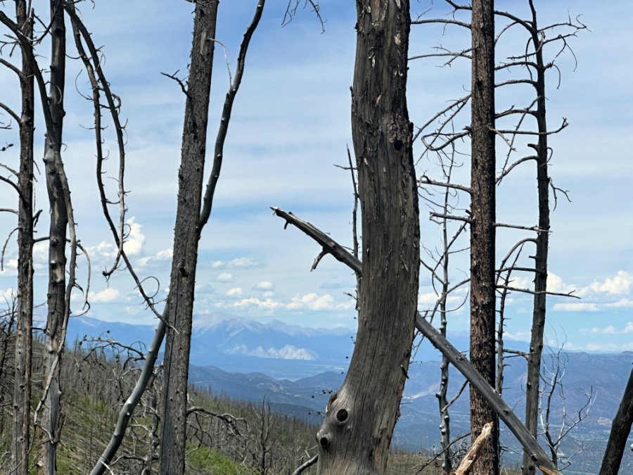
View of Collegiate Peaks through the burn scar around Lake Creek Road up to Rainbow Lake
Horn Creek to Horn LakeS
10.2 Miles | 2885 Feet Elevation Gain | Out and Back Route
Thank you to Jessica, an avid hiker in this area for sharing about this hike.
There are a few hikes in the Sangre de Cristo mountains that I often hike that are similar to this one. But I like this one for the stunning wildflowers and the fantastic views above the lake!
This Westcliffe hike follows Horn Creek to the lake. However, probably the first 1/3 of the trail you're away from the creek, so it takes a while to gain access to it.
At 3.9 miles in, there’s a .2 mile short spur down to one of the smaller Horn Lakes. After this one, keep going to reach the largest lake. The last couple miles before the last lake, there's a plethora of wildflowers to walk through.
Once you get there, it's quite beautiful!
I usually continue up above the lake to a rock that looks down on it. There's not much of a trail to it, and you're bushwhacking a bit through willows, but the view is worth it to me!
COHH PRO TIP: Bring hiking poles, as the trail is quite rocky. Also, pack mosquito repellant.
How to reach the trailhead: Head south out of Westcliffe on Colorado State Hwy 69, Turn right onto Hermit Rd, turn left onto Macey Ln, and then turn right onto Horn Rd, which takes you to the trailhead. You do not need a high clearance vehicle for this drive.

The road leading up to South Colony in Sangre de Cristo Mountains
More WestCliffe Colorado hikes for next time:
South Colony Lakes Trail - We drove up to this trailhead, looking for dispersed camping. Not too many people were up there and we’ve heard great things about the hike. After hiking a a bit on a rocky jeep road, the trail opens up to gorgeous views of Broken Hand and Crestone.
Hermit Lake Trail - A short and easy hike, under 1 mile long — but you’ll need 4x4 vehicle to reach the trailhead.
Rainbow Trail - We saw signs for this one quite often. This long point-to-pont hike includes meadows, wildflowers, views of the Wet Mountain Valley & Pikes Peak views, some challenging stream crossings, large aspen groves, and a nicely recovering burn scar.
Westcliffe Colorado Campgrounds
In my frank opinion, it was harder than we thought to find dispersed or BLM campground that wet our whistle. We searched far and wide for a campsite next to a lake or rushing creek, with ample shade and great views.
We considered camping near Music Pass trailhead. You’ll definitely need a high clearance 4x4 vehicle just to get there.
Or you can camp at lower Music Pass, at the Grape Creek trailhead sign. This spot was nothing impressive in our books, as the creek was tiny and quiet in mid-August when we visited.
We spent all afternoon exploring the different roads, most of which led to the hikes we cover above. For example, Alvarado Campground did not fit our bill, but equestrians would likely love it.

Camping in Westcliffe area at Lake Creek Campground
When we finally reached Lake Creek Campground, we knew this was as good as it gets for forest camping near Westcliffe Colorado.
Our site (#1) was creekside and the rushing waters lulled us to sleep every night. We had plenty of shade, but had to walk around to the campground entrance for any views.
Just 2.2 miles down the road from Balman Reservoir, Lake Creek campground off FS 198 (aka Billy Humble Rd) ended up being the best camping spot for our weekend since we could start our trek to Balman Reservoir Loop from here.
All eleven sites here are first-come, first-served.
COHH PRO TIP: The Wet Mountains are across the valley from the Westcliffe side of the Sangre de Cristo Mountain Range, about 45 minutes away. Many folks suggested Lake Isabel area for camping over there.
Where to Stay in Westcliffe CO
Not into camping but still want to soak in Colorado dark skies and alpine lake hikes?
Our first pick for staying in Westcliffe is this luxury 3-bedroom A-Frame on 35 acres with mountain views — the perfect spot for chilling and star gazing above 8,000 feet.
Our second pick is this large mountain getaway with majestic mountain views in a park-like setting. Great with kids!
Our pick for two families or a large group is Trails Head Lodge, sitting on 80 acres in the middle of the Wet Mountain Valley. Just 3 miles west of Westcliffe and 10 minutes from the Smokey Jack Observatory, this is a great spot for star gazing, all at the foot of the magnificent Sangre de Cristo mountain range.
UTF and ATV Tours
First of all, how does an UTV (utility task vehicle) differ from ATV (all terrain vehicle)?
The UTV often features a roll cage, with some sporting a roof as well. An ATV is controlled more like a motorcycle with handle bars, while UTVs are operated like a car using a steering wheel and foot pedals. Most UTVs also are equipped with seatbelts, which ATVs do not have.
In Westcliffe CO, embark on unforgettable journeys with rugged UTVs, from Hermit Pass to Medano Creek and the Great Sand Dunes. Rent the perfect rock-crawler for your Colorado adventure today with Westcliffe Offroad!
Located nearby in Cotopaxi, Play Dirty ATV Tours operates as the only ATV tour company in Texas Creek permitted on the protected land. Experience challenging terrain and scenic views around every turn with a certified guide.
Dark Night Skies in Westcliffe Colorado
Did you know that Westcliffe Colorado is an international Dark Sky community?
"The International Dark-Sky Association awarded the towns of Westcliffe and Silver Cliff an International Dark Sky Community Designation in 2015. Dedicated to reducing light pollution, Westcliffe pushes for lighting codes and public lighting that doesn’t pollute the night skies. The organization also created awareness in local publications, through dark-sky education and at public events.
Westcliffe and Silver Cliff are the first ever dark sky community in Colorado.
Head to the Smokey Jack Observatory for awesome night sky events, especially around the new moon each month.

A few other dark sky places in Colorado that we love to hike in include:
Ridgway Colorado
Great Sand Dunes National Park and Preserve
Black Canyon of the Gunnison National Park
Mesa Verde National Park
Beers, Brews, and Bakeries in Westcliffe
Here are some favorite stops for coffee, homemade baked goods, or dinner with a drink in this small Colorado town:
Sugarlump Co. was my favorite stop with lots of seating and something for everyone! Enjoy a wide range of espresso based coffee drinks, plus 20+ flavors of ice cream along with milkshakes, smoothies and frappuccinos. Pick up house-made pastries or stay there for a lunch time sandwich, wrap or salad. This is also a great stop for souvenirs and family games. 202 Main Street

Sugar & Spice Mountain Bakery is your small home town go-to spot serving amazing cinnamon rolls, scones, pies and other baked goods, as well as coffee, homemade burritos, jellies and jams, and more. 411 Main Street
Bootleggers Bistro is a local hangout with appetizers, salads, hot and cold sandwiches and a full bar with a wide selection of wines, cordials, and draft beers. A relaxed and comfortable setting with outdoor dining, and three large screen TV’s to watch your favorite team. Open 11am-8pm. Closed on Tuesdays. 306 Main Street
Beeza’s Restaurant & Pub Simple pub-inspired food with an Asian twist - order ramen, burger, or steaks. Open for dinner and drinks Tuesday through Saturday 5pm – 8 pm in beautiful downtown Westcliffe. 215 Main Street
Fishing in Westcliffe

Balman Reservoir is great for fishing
The alpine lakes in the Sangre de Cristo mountains are great for fishing. We saw lots of large, beautiful trout swimming in Balman Reservoir, but we were not lucky that time around.
If you like to hike and fish in remote lakes, Westcliffe is your spot.
The Arkansas River is a short drive from Westcliffe and offers many areas open to the public for rainbow and brown trout fishing right off highly 50.
Be sure to purchase your fishing license. The Ranger stopped by to check for ours. This can be done at the Westcliffe grocery, if you don’t already have one. In Colorado, ages under 16 do not need a fishing license.
When is the Best Time to Go to Westcliffe?
For cooler temps and fall colors, head to Westcliffe in late September early October. Summer hiking can be hot on the exposed sections of trails, so start your hike at sunrise for cooler temps in July and August especially. I bet winter hiking and snowshoeing is lovely here as well.
While driving to trailheads you’ll see big, tidy ranches everywhere. This is also an Amish community, so watch out for the occasional horse and buggy, although we didn't see one.
Westcliffe is a small, quiet mountain town with a super cute main street and fun local businesses, like the All the Range Mountaineering and Outdoor Gear Store. If you have questions about the area, stop in there. They got out a map to show us around and they are so happy to help!
In Westcliffe, you are not far from Hwy 50 along the Arkansas river. From Westcliffe, you can easily head toward Cotopaxi, the Royal Gorge, Salida and Buena Vista. And don’t forget, the Great Sand Dunes are just on the other side of the Sangre de Cristo Mountains!
Related Reading: Escape to the Rocky Mountains to one of these 13 destinations on the Ultimate Colorado Family Vacation — Summer 2025.

Great Sand Dunes on the other side of the Sangre de Cristo mountain range
Safety Precautions While Hiking Colorado Trails
Plan Ahead: Always tell someone know where you’re going and when you think you’ll return. Leave a note on your car seat with the information as well.
Pack Essentials: Carry plenty of water, food, warm clothing, a map, a compass, a first-aid kit, a flashlight or headlamp, and a whistle for eveyone in your group
Stay on Designated Trails: Heading out on your own can lead to getting lost and can damage the natural environment.
Check the Weather: Weather in mountainous regions can change rapidly. Make sure to check the forecast before hitting the trail and be prepared for all types of weather. Be ready to ditch your plans and choose another adventure for the day.
Know Your Limits: You know you. You know your physical limitations and when it’s time to turn around. Speak up when hiking with your friends and turn back if conditions are too challenging.
Stay Alert: Be aware of your surroundings, including wildlife, changes in the weather, trail conditions, and your own health.