
Tackling Colorado 13ers: Five Top Hikes We Love in 2025
This post may contain affiliate links. This just means if you make a purchase, we may make a small commission at no extra charge to you! Thank you for your support!
Conquering Lesser-Known Mountains: Tackling Majestic 13ers

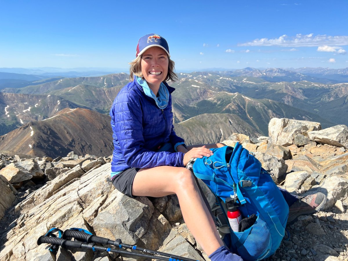
At the top of Mount Ouray
With towering peaks, breathtaking vistas, and a sense of accomplishment like no other, we have found conquering majestic 13ers in Colorado to be a thrilling adventure.
The hikes we have covered here are lesser-known mountains, just a notch below the famous 14ers, but don't let us fool you – they offer their own unique challenges and rewards.
We strapped on our favorite hiking boots and trusty daypack to tackle some of the best 13ers in Colorado.
How many 13ers in Colorado?
The Centennial state is home to over 637 mountains ranging between 13,000 and 13,999 feet in elevation, commonly called 13ers.
The rugged terrain of the five 13ers we’ve hiked will demand your grit and determination as you ascend steep slopes and negotiate rocky trails.
The payoff is worth every step: enjoy panoramic views as far as the eye can see of the unmatchable Rocky Mountain Range.
Often overlooked by their taller 14er siblings, we believe hiking Colorado 13ers offer a quieter retreat, since we encountered way fewer hikers.
On the tops of 13ers, we were able to embrace solitude and find respite from the chaos of everyday life.
We say show up prepared, be ready to respect the natural environment, and get ready to experience the thrill of standing on top of the world.
Summiting Grays and Torreys
What Makes 13ers Different From 14ers?
When it comes to mountains, we immediately wonder “How tall?” or “How much elevation will I be climbing?” Certainly, Colorado's famous 14ers, mountain peaks that tower above 14,000 feet, attract hikers from all over the world.
However, Colorado 13ers — peaks that stand between 13,000 and 14,000 feet — have their own charm and attraction and solitude.
One of the primary differences between 13ers and 14ers is the sheer amount of them. With over six hundred 13ers, yet only fifty-eight 14ers in Colorado, 13ers offer many more accessible experiences for hikers of all kinds of skill levels.
The best part about hiking 13ers? Way less people! The trails on 13ers tend to be less crowded, allowing for a more serene and intimate connection with nature. In fact, you may not see anyone else at all!
Additionally, the lower elevation sometimes means the weather conditions are more manageable — and the risk of altitude-related illnesses is a bit less. But don’t fool yourself, many 13ers are tough and just as exposed. Know what you’re up for before you go.
Let me say this: reaching the top of a 13er is just as rewarding as tackling a 14er. These 13er mountains below offer stunning views in the unforgettable Rocky Mountains.
Essential Gear and Preparation for Tackling Colorado 13ers
Preparing for a hiking 13ers requires careful planning and the right gear to ensure a safe and enjoyable experience. Here are some essential items to consider packing for your 13er hike:

Hiking poles make Colorado 13ers easier on the knees
Hiking Boots: A sturdy pair of hiking boots is a must. I love ones that provide ankle support and traction. The rugged terrain of the 13ers demands footwear that can handle rocky trails and steep slopes.
Hiking Poles: Did you know that when you use trekking poles, you're getting a full body workout? Hello toned arms and shoulders. Also, according to The Sport Journal, using hiking poles can reduce compressive force on your knees by up to 25%. Learn all the benefits of using hiking poles.
Backpack: Strap on a comfortable backpack that offers enough room to carry all your essentials, like lots of water, snacks, extra layers of clothing, a first aid kit, and navigation tools. We love the Opsrey Sirrus and Stratos series.
Navigation Tools: Carry a map, compass, and/or a GPS device to help you find your way to the top of your Colorado 13er. Familiarize yourself with the route beforehand and always be prepared for changing weather conditions. Summer in Colorado means thunderstorms often roll in around noon, so start your hike early and prepare to have a Plan B — it’s okay if you don’t summit!
Layered Clothing: Colorado's mountain weather can be unpredictable, so it's essential to dress in layers. Start with a moisture-wicking base layer, add insulating layers, and top it off with a waterproof and windproof outer shell. Among some of our go-to things of what to wear while hiking:
Patagonia Torrentshell Rain Jacket
Nano Puff Jacket - an excellent three season jacket and layer
Food and Water: Take along high-energy snacks and plenty of water to stay hydrated throughout the hike. Consider bringing a water filter or purification tablets for refilling water from natural sources, in case you run out of water. LINK AND LIST SUGGESTIONS
Sun Protection: Protect yourself from the sun's harmful rays by wearing sunscreen, sunglasses, and a hat. The higher altitude can intensify the sun's effects, so lather on the sunscreen before you hit the trail.
Emergency Essentials: Carry a whistle, flashlight, and a lightweight emergency shelter in case of unexpected circumstances. It's always better to be prepared for any situation.
Know your limitations - Are you in shape for this hike? Also, please be aware of the signs of altitude sickness awareness; every person fairs differently in altitude. Experiencing a headache, feeling sick, dizzy, tired, loss of appetite, or shortness of breath? Step one: drink more water! And there is no shame in turning around or telling your hiking buddies you don’t feel well.
Allow yourself plenty of time to summit a Colorado 13er: Thunderclouds and storms roll in quick in the Rocky Mountains. Some 13ers may take as long as one hour per mile of hiking, especially the steep ones. Also, begin your hike early in the day to increase your chances of summiting well before early afternoon thunderstorms roll in. Hitting the trail by 6 am in summer is quite common!
Permits and Regulations: Some 13ers may require permits or have specific regulations, so check with the local authorities and obtain any necessary permits before your hike.
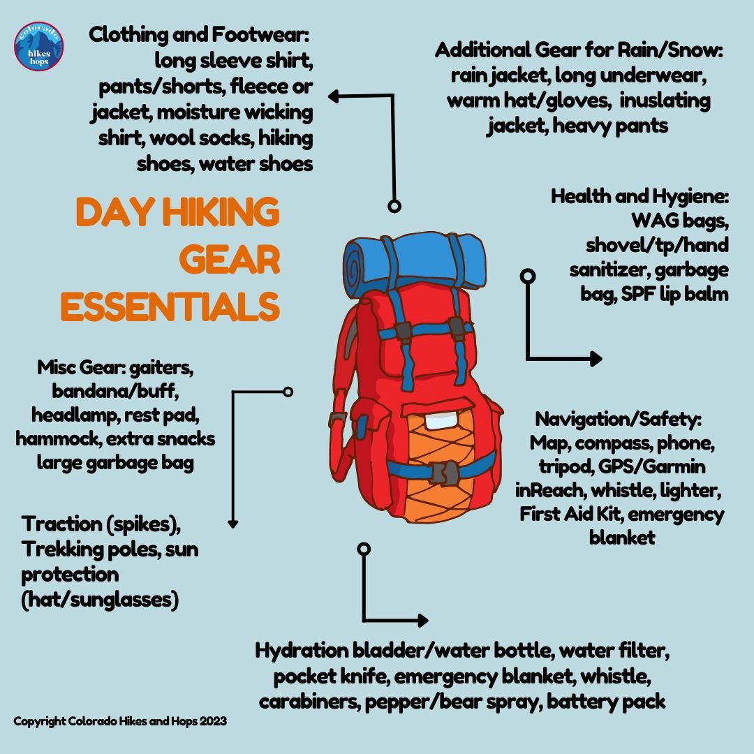
Day Hiking Gear for 13er hiking in Colorado
Proper preparation and the right gear are crucial for a safe and enjoyable experience hiking 13ers in Colorado. Plan accordingly, making sure you have everything you need for a successful hike.
RELATED: Beginner Hiking Tips for Colorado
Must Have Gear for Colorado Hiking Trail in 2025
We love the Osprey Sirrus Hiking Daypack for women, or the Stratos version for men, for carrying water, layers, and snacks on Colorado day hikes
Lightweight, versatile Hiking Poles built for a full day’s send on the trail — hike longer and stronger
2L or 3L Water Reservoir — This affordable reservoir is easy to fill
Patagonia Torrentshell - a true waterproof rain jacket and fantastic layering piece
Nano Puff Jacket - our favorite for 3 seasons in Colorado
Smartwool Glove Liners - the best all season gloves for those high altitude hikes
Salomon hiking shoes - waterproof, comfy and hard working for any type of hike

You never know when you might need a true rain jacket
Our Favorite 13ers to Hike in Colorado
Colorado is home to a staggering number of 13ers, 637 of them to be exact, but not all peaks are created equal.
Here are our five must-hike 13ers, in no particular order, that offer a range of challenges and breathtaking views:
Mount Ouray via Grays Creek Trail
Square Top Mountain
Mount Flora
North Star Mountain
Mount Sniktau, Cupid Peak, and Grizzly Peak
Mount Ouray via Grays Creek Trail
Elevation: 13,977’ Distance: 8.34 miles Elevation Gain: 4,300’

The 360 views from the top of Mount Ouray, a 13er in Colorado
While there is another route, Tanya suggests beginning your hike to Mount Ouray via Grays Creek Trail.
This Colorado 13er is not for the faint of heart, but totally worth it! Here are my trail notes:
The hike up Mount Ouray is a steep and steady climb the entire way. Very rocky. Mile 3 was the toughest, as we navigated huge boulders and followed sporadic cairns.
Note there is also a lot of scree for the final steep ascent, but it’s not technical.
The final mile of the ascent to the top was my favorite! We hiked this on the first day of fall and lucked out with fantastic weather, allowing us to enjoy the views and refuel at the top for a while.
I’m talking FABULOUS 360 vistas. It felt like we could see every mountain in Colorado.
You would be wise to bring hiking poles, a windbreaker, layers, 3 L of water and LOTS of snacks.
Since it was September 20th when my friend and I hiked Mount Ouray via Grays Creek Trail, the leaves in the aspen groves were just beginning to turn. We experienced just a little bit of wind here and there. Many hikers reported heavy winds during their hikes.
We got a later start than we anticipated; we began our hike at 8:40 am and finished about 7 hours later.

Mount Ouray as seen from Devil’s Chair
We stopped at Devils Chair (great views from here as well!) for a 20 minute break, then we stopped before the final ascent and again at the top.
Clouds and a bit of rain rolled in right as we finished our descent back to our car around 3:45 pm.
Check the weather before you go as you are exposed to sun and weather entirely after the first two miles.
Hike this 13er with a friend, because it is quite challenging and there is the chance you will not see another soul. We only saw three others at the top. In fact, I fell once on the way down and nearly jacked my knee; with so many rocks to navigate, the hike down is tough when your legs feel like jelly after climbing up 4,200+ feet!
how to reach the trailhead
Follow US-24 W/W Hwy 24 and US Hwy 285 S to Marshall Pass Rd in Chaffee County. You will pass the mountain town of Salida along the way.
You will drive Marshall Pass Road for 7.2 miles. You will pass Ohaver Campground along the way.
PRO TIP: There is another route for hiking Mount Ouray. Note it is a highly challenging route, best for experienced hikers.


Favorite Breweries in Salida
SOUL CRAFT BREWING This Salida Colorado brewery hones in on fresh craft beer in a chill setting, with both indoor and outdoor seating. Featuring 16 beers on tap, try the High and Unstable Dopplebock or the X-Ray IPA. 248 W Rainbow Blvd, Salida, CO 81201
TRES LITROS BEER COMPANY Try the Bourbon Beckerbier or the Electrólima Mexican Lager or grab a flight while you cool off at this brewery in downtown Salida. 118 N E St, Salida, CO 81201
More hikes near Salida
Two of the best mountain towns, Salida and Buena Vista offer small-town charm while providing a gateway to loads of outdoor adventure along the Arkansas River and among the Collegiate Peaks in the Sawatch Range of the Colorado Rockies.
A mere 24 miles separate the two towns, meaning you can tackle all the hikes in this area, no matter where you are staying.
Camping
You can’t beat O’Haver Campground. Tanya and her friend snagged an open first come first served sight during the middle of the week.
This campground fills quickly, even before Friday. Thankfully O’Haver Campground offers reserved sites, as well as ten first-come, first served sites. Show up on Wednesday or Thursday for your best chance at securing a last minute site.

The fishing dock at Ohaver Lake Campground with Mount Ouray in the background.
lodging
Hiking with a larger group or family? Book a gorgeous mountain home like this one, with spectacular view of Chalk Cliffs and Canyon, just right up the road from Mount Princeton Hot Springs.
Or try the AMIGO MOTOR LODGE sitting on Highway 50. This modern, southwestern themed motel isn’t far from the Arkansas Headwaters Recreation Area. We say stay the night in one of their sweet Airstreams. 7350 US-50, Salida, CO 81201
Square Top Mountain
Elevation: 13,786’ Distance: 7.0 miles Elevation Gain: 2454’
Tanya and a friend hiked to the top of Square Top Mountain at the end of September. While it’s a steep hike to reach the top of Square Top Mountain, 13,785 feet, we enjoyed ideal weather and stellar views.
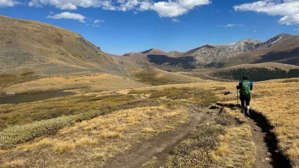
Starting off on the hike to Square Top Mountain, a 13er in Colorado.
We were completely exposed on the trail the entire time. It was a bit breezy here and there but nothing horrible.
The aspens lining Guanella Pass were turning to gold, making for a gorgeous fall day.
You will actually hike down a bit in elevation, before heading up. You’ll hike through a forest a bit, but you will also be quite exposed while hiking.
This challenging 13er hike pays off in fabulous views of mountains, plus three lakes. You can take a spur to sit by one of the 3 Square Top Lakes on your way back down.
Should you decide to hike over to the lake on the way up, know that afterward, you will climb up, up, up for the remaining 1700 feet of elevation gain to the summit of Square Top Mountain.
The wildflowers are insane in summer. This area can be windy, so pack layers accordingly. Some hikers choose to snowshoe this trail in winter.

Grays and Torreys Peak off in the distance, as seen from the top of Square Top Mountain.
Once at the summit, you’ll enjoy marvelous views of Grays & Torreys Peak to the west and Sawthooth Ridge joining Mount Bierstadt and Mount Blue Sky together, to the east.
Allow yourself about 4 hours to complete this hike. Make sure you are ready for hiking in high elevation. Aim to be back below tree line by 1 pm. Always check the weather forecast before you hike.
After your hike, relax and soak your weary bones at Indian Hot Springs in Idaho Springs after your hike. 302 Soda Creek Rd, Idaho Springs, CO 80452
Related Reading:
17 Colorado Hot Springs Calling for a Dip in 2025

how to reach the trailhead
Coming from Denver, take exit 228 off of I-70 W, then drive about 11 miles on Guanella Pass to the trailhead. The parking lot for Square Top Mountain trailhead is called Guanella Summit.
NOTE: Guanella Pass closes annually between November - March. Check for road closures. When Guanella Pass Road is closed during the winter, the closure point is at Naylor Lake on the Clear Creek County side and at Burning Bear Campground on the Park County side.
Colorado Breweries nearby
Craft Mountain Brewing Company in Bailey, Colorado (nearer to Grant)
Highside Brewing Company in Fairplay, Colorado (nearer to Grant)
Guanella Pass Brewing Company in Georgetown, Colorado
More hikes along Guanella Pass
Guanella Pass is in the Mount Blue Sky Wilderness (formerly called Mount Evans Wilderness), between the towns of Georgetown at the north end and the town of Grant at the south end, where US Hwy 285 intersects.

Hiking the Abyss Trail to Helms Lake, off Guanella Pass in fall
There are lots of great hikes along Guanella Pass.
Camping
Campgrounds options on south end of Guanella Pass:
Burning Bear Campground
Geneva Park Campground
Campgrounds options on north end of Guanella Pass:
Guanella Pass Campground
Clear Lake Campground
RELATED: Ultimate Guide to Camping in Colorado
Lodging
Near the south entrance of Guanella Pass, the small mountain towns of Bailey and Jefferson are great spots for recommended lodging listed below. They are along Kenosha Pass and more great hiking.
BAILEY
This cozy mountain lodge in Bailey is just minutes from Guanella Pass hiking. Enjoy the wrap-around deck and six-person hot tub for star gazing year round.
JEFFERSON
Between Guanella Pass hikes, relax in this 3 bedroom Jefferson, Colorado vacation home set on 100 acres of land with grazing pastures and spectacular views. Go fishing in nearby Jefferson Lake. Jefferson is just fifteen minutes from the start of Guanella Pass in Grant.
GEORGETOWN
Stay in historic Georgetown just a few miles from Guanella Pass hikes and other Rocky Mountain adventures.
IDAHO SPRINGS
Idaho Springs is another historic Colorado mountain town offering remodeled historic vacation homes and fun local places for food and drink.
Mount Flora
Elevation: 13,142’ Distance: 6.3 miles Elevation Gain: 1788’ Time to complete: 4 hours
This easy 13er in Colorado is near Denver and makes for the perfect day trip, since it’s just off I-70 in Idaho Springs.
Melody made the trek with two younger teenagers in early August and it was a great hike for older kids, albeit very crowded!

Mount Flora is a a great 13er near Denver
Arriving at the trailhead at 7:30 am and the trail was packed. Again, another busy area for many hikes.
You’ll park at Berthoud Pass, where you’ll find bathrooms, maps, and a visitor center.
The beginning of the hike starts on a large wide road at start, then heads of on a well marked trail to the left. Just watch for the signs pointing the way.
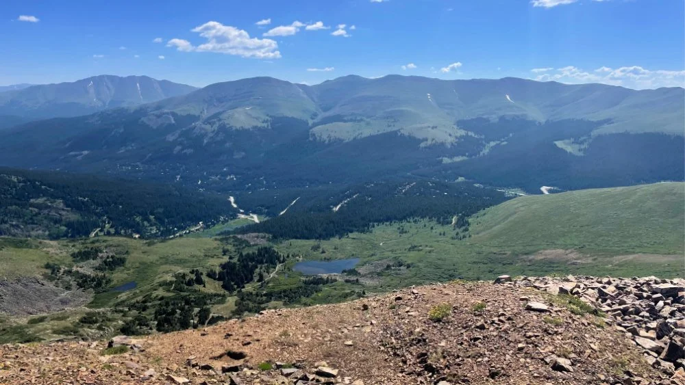
Enjoy gorgeous views the entire way, including lakes below you.

Views from the hike up Mount Flora
Be aware there is a false summit or two. Download a map and keep your pace slow and steady. The trail is mostly gravel and dirt with some rocks as you summit.
Note, there is not much room for passing people do bring dogs on this hike, but they were mostly leashed.
The summit at the top is broad and can easily hold one hundred people. We joined forty others the day we were there.
Pack a lot of layers, as wind can be excessive some days.
Experienced hikers take on Mount Flora in winter with snowshoes and spikes and love it.

For an easy 13er in Colorado, hike up Mount Flora
How to reach the trailhead
Take exit 232 from I-70 West. Follow US-40 W for nearly 15 miles to your destination: Berthoud Pass parking lot. Seasonal road closures do occur in winter.
Below is a video taken from the top of Mount Flora.
Favorite Stops nearby
After your hike, stop at the Empire Dairy King for ice cream and more in Empire, about 3 exits west of Idaho Springs. Amazing malts, shakes and burgers too. While nothing to write home about from the outside, this shake shack offers some of the best ice cream in the area. Fun way to refuel after you’ve tackled a Colorado 13er.
More hikes nearby
On Tanya’s list, near Winter Park is hiking Stanley Mountain via Berthoud Pass West and Mount Nystrom Trail. This moderate trail takes you over seven miles through summer wildflowers and boasts gorgeous views, taking you up to over 12,600 feet in elevation.
There are lots of great hikes along Guanella Pass.
Camping
Try Midland Campground or Robbers Roost off of US 40. We have drive by both frequently, but have not had the chance to try either yet. A lot of people also rave about St. Louis Creek Campground.
Lodging
Try the beautiful Clear Creek Inn in Georgetown. Located in historic downtown Georgetown, Clear Creek Inn is a warm, comfy space surrounded by mountain views.
Enjoy this gem in Georgetown, perfect for four people. Close proximity to Clear creek and Georgetown Lake as well as all the shopping and restaurants downtown.
North Star Mountain
Elevation: 13,462’ Distance: 7.4 Elevation Gain: 2106’
A lesser trekked Colorado 13er near Breckenridge in Summit County, North Star Mountain doles out insane views of nearby 14ers without the crowds.

Cairns along the way to North Star Mountain
Aim to reach the trailhead parking lot at Hoosier Pass early, like 6 am, so you can get a spot. Melody hiked this in mid July and the parking lot was nearly full by 6 am since it is a very popular trailhead for many trails in the area.
Due to competition with nearby 14ers, the North Star trail sees way less traffic. Melody and her crew only passed a handful of people the entire day.
Many folks just hike to the small lake — which was a mud hole in July that summer.
Cairns mark the way for most of the trail, but we encourage you to download a map in AllTrails as there is no cell reception.
NOTE: Just pass the turn off to the right for the lake, head LEFT towards a metal gate. You’ll head up this route vs. just heading straight up. The trail is not well-marked, so be sure to consult your map frequently and read recent hikers’ commentary on AllTrails.
At the top, you will be rewarded with insane views of 14ers.

Views from the top of North Star
PRO TIP: Reaching the top may feel sketchy and rocky because you have to walk along a VERY narrow strip to get to the actual top of North Star. Those who hate heights will not enjoy this part.
Overall, the best parts of hiking to to the top of North Star are the summer wildflowers and the insane views without many people.
How to reach the trailhead
The trailhead is located in the large parking area west of CO Hwy 9 atop Hoosier Pass. The pass can be reached by traveling CO 9 south out of Breckenridge or north out of Fairplay. The trailhead is accessible year around.
Hiking to the top of North Star
Favorite Stops nearby
Motherloaded Tavern From cocktails to favorite Breckenridge breweries finest beers, this is a must stop at least once on your summer trip. While everything on the menu is great, their burgers are home runs. 103 S Main St, Breckenridge, CO
The Canteen Tap House and Tavern With a modern take on the old classicsthis tap house serves up some of the best sandwiches, soups and salads after a hike near Breckenridge. Cocktails served up in cute metal canteen cups. 208 N Main St, Breckenridge, CO
Sancho Every taco on this menu is finger lickin’ good. Fantastic margaritas. Vegan, vegetarian and meat options, so there’s something for everyone. 500 S Main St, Breckenridge, CO
More hikes nearby around Breckenridge
Melody’s 17 impressive hikes in Breckenridge and nearby Eagles Nest Wilderness are summer trails to come back to over and over again- they are just that stunning!
Summer in Breckenridge attracts locals and tourists with wildflower hikes, alpine mountain treks, numerous mountain biking trails, fly fishing on the Blue River and water sports on nearby Dillon Reservoir. Throw in ATV escapades and horseback riding through the 2.3 million acres of White River National Forest, plus off road jeeping and you got one heck of a well rounded Colorado summer vacation.

Prospector Campground in Summit County
Camping
Reserved sites at Prospector Campground, situated in the midst of White River National Forest, this Summit County campground overlooks Dillon Reservoir, one of Colorado’s largest manmade lakes.
Picturesque mountain views offer idyllic camping in Colorado, combined with easy access to fishing make this the perfect family friendly camping retreat.
Biking, hiking, boating, stand up paddle boarding and fishing are just minutes from the campground.
Lodging
From sweet mountain homes to exceptional condos on the peaks of Breckenridge the possibilites are endless for staying near all the fun restaurants and shops on Main Street in Breck.
Mount Sniktau, Cupid Peak, and Grizzly Peak
Highest Elevation: 13,412’ Distance: 7.6 miles Elevation Gain: 3497’
This hike makes for a super fun triple peak day. Yes, you can knock out three Colorado 13er peaks in one day!
These 13er peaks in Colorado are near the town of Dillon and takes you along the Continental Divide.

The view from Mount Sniktau
This is a mostly standard Colorado hiking trail to Sniktau and Cupid, with some rocks to navigate. On your way up to Grizzly, large rocks became the theme.
Each of these three 13er peaks can be seen from A Basin, while driving over Loveland Pass. You will park at Loveland Pass — a large dirt shoulder that fills fast in warm months. Begin this hike very early, by 6:30 am is best.
NOTE: This 13er hike is often windy since you hike above treeline the entire time.
Keep reading to learn the best way to summit each peak.
Aim to summit Mount Sniktau first, followed by Cupid (known as one of the easiest 13ers in Colorado), then finally Grizzly Peak. However, some suggest tackling Grizzly Peak first.
The first mile of this hike is a super wide trail. Melody followed notes of other hikers and took the cutoff trail at saddle between Cupid and Sniktau to get back to the car, so we didn’t get to Grizzly Peak. This was her fourth day of hiking and they were tanked!
After some intel, we knew the hardest trek is between Cupid and Grizzly; tons of hills with loose gravel, which is Class 2 in 14er language.
PRO TIP: I talk about all the classes and what they mean in our 14er post.
While descending this hike, you’ll snag a fantastic view of A Basin ski resort. You’ll also enjoy stunning views of Grays and Torreys Peaks, 14ers in the area.

The trail leading to Cupid Peak, an easy Colorado 13er
In area you could do the following hikes over a few days: Mount Flora (covered above), Pitkin Lake (gorgeous hike we’ve done on repeat), Quandary (easy 14er and covered in our 14er post) and this triad of three 13ers.
How to reach the trailhead
From I-70 W, take exit 216 and continue on US-6 West for 4.4 miles until you reach Loveland Pass.
Top Breweries and Eateries nearby
Outer Range Brewing Company Focused on brewing the great styles of craft beer that inspire us—Belgians and IPAs. The eatery, Bird Craft, is inside the brewery and serves Thai- inspired dishes that pair perfectly with their brews. 182 Lusher Ct, Frisco, CO
Angry James One of many great micro breweries in Summit County, here you’ll find a great selection of beers after your hike. 421 Adams Ave, Silverthorne, CO
Mercado La Perla in Silverthorn Who doesn’t like tacos after a hike? Head to this lunch spot for real Mexican food! Try the carne asada or chorizo tacos for lunch. 1161 Blue River Pkwy, Silverthorne, CO
Pug Ryan’s Brewery This rustic, cabin-style steakhouse and brewpub serves traditional American food and in-house beers. 104 Village Pl, Dillon, CO

Grizzly Peak
More hikes
As mentioned above under North Star, these 17 impressive hikes in Breckenridge are worth checking out.
Camping
Try Lowry Campground between Frisco and Dillon. Clear Lake Campground and Guanella Pass Campground are also great options.
RELATED: Ultimate Guide to Camping in Colorado
Lodging
In the summertime, the ski town of Frisco turns up the heat on summer fun. The slopes offer hiking and biking trails and Lake Dillon Reservoir fills up with sailing boats and kayaks.
Base yourself in Frisco in a sweet little cabin for a fun Colorado vacay filled with hiking and all kinds of outdoor adventures.
Conclusion
We believe conquering some of the best 13ers in Colorado is a thrilling adventure that offers a unique and rewarding experience. From the challenging hikes to the breathtaking panoramic views, these lesser-known peaks helped us push our limits while diving into the beauty and solitude of the Rocky Mountains.
Whatever Colorado hiking trails we set off on, we remind you to be prepared and respect the environment. The sense of accomplishment and the indescribable thrill of standing on top of a Colorado 13er will make all of your preparation worth it!
What 13ers have you hiked in Colorado? We’d love to hear about your experience.